You're all caught up—no notifications available.
Explore All Exams at KGS

All Exams
Explore All Exams at KGS
Khan Sir Courses
Geography I Polity I History | World Map I Indian Map I Economics I Biology
UPSC & State PSC
UPSC I BPSC I UP-PSC I MP-PSC
State Exams
UP I Bihar I MP | Rajasthan
NEET | JEE | CUET
NEET | JEE | CUET
Defence Exams
NDA I CDS I CAPF I AFCAT I SSB I Agniveer
Police Exams
UP SI | Bihar SI | Delhi Police | UP Constable
SSC Exams
CGL I CPO I CHSL I MTS I SSC GD I Delhi Police
Foundation Courses
Physics I Chemistry I Biology I History I Geography I Polity I NCERT I Math I English | Map I Reasoning
Railway Exams
RRB | RPF
Teaching Exams
TET | Teaching | UGC
Banking Exams
SBI | RBI | IBPS
Engineering Exams
Civil | Electrical | Mechanical
UGC NET
UGC NET/JRF
Current Affairs provides you with the best compilation of the Daily Current Affairs taking place across the globe: National, International, Sports, Science and Technology, Banking, Economy, Agreement, Appointments, Ranks, and Report and General Studies

SYLLABUS
GS-3: Science and Technology- Developments and their Applications and Effects in Everyday Life; Indigenization of Technology.
Context: India has significantly expanded its Doppler Weather Radar (DWR) network over the past decade to strengthen its weather monitoring and forecasting capabilities
More on the News
• India’s DWR network has grown from 14 radars in 2014 to around 50 in 2026, representing an increase of over 250%.
• The current network provides coverage to approximately 85–87% of India’s geographical area, significantly improving real-time weather monitoring.
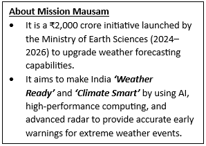
• Under the government’s Mission Mausam initiative, additional radars are planned to further enhance coverage, especially in coastal, mountainous, and disaster-prone regions.
• Future plans aim to expand the network to over 100 radars, enabling near-complete national coverage and improved accuracy in forecasting.
• The expansion is accompanied by advancements in dual-polarization radar technology, which enhances the ability to distinguish between different types of precipitation.
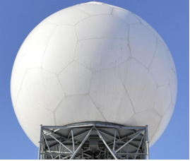
About Doppler Weather Radar (DWR)
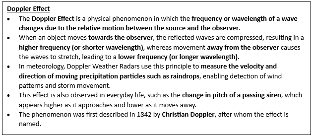
• Doppler Weather Radar is a remote sensing system that uses the Doppler effect to measure the velocity and movement of atmospheric particles such as raindrops, snow, and hail.
• It operates by emitting microwave signals and analysing the frequency shift of the signals reflected back from moving objects.
• Modern DWRs provide high-resolution, real-time data on precipitation, wind patterns, and storm intensity, enabling short-term forecasting or “nowcasting.”
• These radars play a crucial role in tracking cyclones, thunderstorms, and severe weather systems with high precision.
• Types of DWR:
Working of DWR
• The radar transmits pulses of electromagnetic waves into the atmosphere, which are reflected back by precipitation particles such as raindrops.
• The time taken for the signal to return helps determine the distance of the weather system, while the frequency shift (Doppler shift) indicates the speed and direction of movement.
• Advanced DWRs use dual-polarization technology, sending signals in both horizontal and vertical orientations to identify the type and shape of precipitation.
• The collected data is processed and integrated with weather models to generate accurate forecasts and early warnings.
Applications of DWR
• Weather Forecasting and Nowcasting: DWRs enable accurate short-term predictions of rainfall, thunderstorms, and severe weather events, improving forecast reliability.
• Disaster Management: They play a critical role in issuing early warnings for cyclones, floods, and lightning, helping reduce loss of life and property.
• Agriculture and Water Management: Farmers benefit from timely weather information for crop planning, irrigation, and pest management, while water authorities use it for reservoir management.
• Aviation and Maritime Safety: DWR data supports safe flight operations and navigation, particularly during adverse weather conditions.
• Urban Planning and Climate Resilience: High-resolution data helps in urban flood management, infrastructure planning, and climate adaptation strategies.
SOURCES:
PIB
Newsonair
Indian Express
PIB

The most trusted learning platform on your phone
With our training programs, learning online can be a very exciting experience! Take the next step toward achieving your professional and personal objectives
Course Related Query:
Ask Your DoubtsStore Related Query:store@khanglobalstudies.comNCERT Books
Resources
We love learning. Through our innovative solutions, we encourage ourselves, our teams, and our Students to grow. We welcome and look for diverse perspectives and opinions because they enhance our decisions. We strive to understand the big picture and how we contribute to the company’s objectives. We approach challenges with optimism and harness the power of teamwork to accomplish our goals. These aren’t just pretty words to post on the office wall. This is who we are. It’s how we work. And it’s how we approach every interaction with each other and our Students.
Come with an open mind, hungry to learn, and you’ll experience unmatched personal and professional growth, a world of different backgrounds and perspectives, and the freedom to be you—every day. We strive to build and sustain diverse teams and foster a culture of belonging. Creating an inclusive environment where every students feels welcome, appreciated, and heard gives us something to feel (really) good about.
Get Free academic Counseling & Course Details


